 Lapsed, fee not paid6 drawings
Software & Apps · US 9,766,744 B2
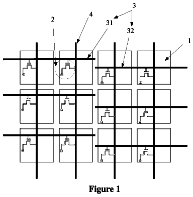
Touch display panel, and driving method and driving circuit for the same
It is provided a touch display panel, and a driving method and a driving circuit for the touch display panel.
US 9,766,783 B2 · Assignee: Facebook, Inc. · Inventors: Watson; Thomas Andrew et al.
Sheet 1 of 5 from the published document. All sheets in the USPTO PDF
A map interface presents a geographic map with markers identifying geographic locations associated with content items. When the geographic distance between two or more content items is less than a threshold distance, multiple content items are grouped to create an aggregated content item. Based on the geographic locations associated with the grouped content items, a geographic location is associated with the aggregated content item. A single marker identifies the geographic location for the aggregated content item on the geographic map. When a user viewing the map interface accesses the single marker, content selected from the content items combined to generated the aggregated content item is presented as well as the geographic location associated with the aggregated content item.
This invention relates generally to social networking and, in particular, to aggregating and displaying geographic information about users of a social networking system. Social networking systems capture and store large volumes of information from various sources. Information stored by the social networking system will often be associated with a geographic location. When providing information about a user a social networking system may present a map interface including markers indicating geographic locations of different types of information pertaining to the user. For example, a map interface may present markers identifying geographic locations associated with photos of the user and comments posted by the user while at the marked geographic location. However, as the social networking system accumulates more information about the user over time, it becomes difficult to read the informati
All 5 drawing sheets from the published document, cropped to the drawing.
What the patent claimed, word for word. All of it is now free to use.
This invention relates generally to social networking and, in particular, to aggregating and displaying geographic information about users of a social networking system.
Social networking systems capture and store large volumes of information from various sources. Information stored by the social networking system will often be associated with a geographic location. When providing information about a user a social networking system may present a map interface including markers indicating geographic locations of different types of information pertaining to the user. For example, a map interface may present markers identifying geographic locations associated with photos of the user and comments posted by the user while at the marked geographic location.
However, as the social networking system accumulates more information about the user over time, it becomes difficult to read the information on the map interface. For example, the map interface may become cluttered as the system obtains and displays new information as the user adds new photos, friends, and other information associated with a location. Although viewers of a map interface may be able to discern one map marker from another, this will not always be the case. For example, viewers may wish to browse information about a user's visit to a particular location, but markers identifying the user's visits to other nearby locations may make it difficult to identify the marker corresponding to the particular location.
Furthermore, as a variety of information related to geographically close locations is captured in large volumes by the social networking system, aggregating the information into compact, yet information structures, allows viewers to more efficiently consume such information. In addition, information from a certain location often is related to other information from nearby locations, making it desirable to associate or display such information together. For example, it may be interesting for viewers to see photos of a user from his vacation in conjunction with that user's status updates from the same vacation. However, if the map interface displays information segmented by individual map markers at geographically close locations, viewers wishing to view the user's overall vacation information are forced to individually identify map markers to retrieve information. This makes it difficult to concurrently view different types of information related to a particular location.
A map interface may be used to identify geographic locations associated with content items. For example, a map interface associated with a social networking system user identifies geographic locations associated with content items that are associated with the social networking system. The map interface may display a marker on a geographic map to identify the geographic location associated with one or more content items. However, a zoom level associated with the map interface may be modified to increase or decrease the scale of the map interface. Modifying the zoom level often reduces the distance between the markers displayed by the map interface. As the distance between the markers displayed by the map interface is reduced, it becomes more difficult for a user viewing the map interface to select specific markers, making it difficult for the viewing user to access the content items associated with geographic locations identified by different markers.
To allow a viewing user to more easily retrieve content items associated with different geographic locations from the map interface, content items may be combined to generate an aggregated content item. A geographic location is associated with the aggregated content item and a marker is displayed on the map interface identifying the geographic location associated with the aggregated content item. To generate an aggregated content item, a plurality of initial content items, each associated with a geographic location, is accessed. A threshold distance is determined based on the zoom level used to present the map interface. A pair of content items associated with the geographic locations that are closest to each other is selected form the initial content items. The distance between the geographic locations associated with the selected pair of content items is compared to the threshold distance, and if the distance is less than or equal to the threshold distance, an aggregated content item is generated that includes both of the selected pair of content items. Based on the geographic locations associated with the selected pair of content items, a geographic location is determined and associated with the aggregated content item.
Various factors may be used to determine the geographic location associated with the aggregated content item. For example, the geographic location associated with the aggregated content item is based on a weighted average of the geographic locations associated with the pair of content items. The weights may be based in part on a time associated with each content item in the pair of content item, affinities of a viewing user for each of the content items in the pair of content items, or any other suitable criteria or combination of criteria. Alternatively, the geographic location associated with the aggregated content item may be determined as the geographic midpoint between the geographic locations of the selected pair of content items.
In one embodiment, pairs of content items, including aggregated content items, are selected and continue to be aggregated until the shortest distance between geographic locations associated with a pair of content items is larger than the threshold distance. A map interface including one or more aggregated content items, or markers identifying a geographic location associated with an aggregated content item, is sent for display to a viewing user. Markers identifying one or more geographic locations associated with an initial content item may also be displayed via the map interface. By accessing an aggregated content item via the map interface, a viewing user receives information describing one or more of the content items combined to form the aggregated content item, allowing the viewing user to access various content items via the aggregated content item.
An information display may be presented when the viewing user interacts with a marker identifying a geographic location associated with an aggregated content item. The information display presents one or more content items included in the aggregated content item and identifies the geographic location associated with the aggregated content item. In one embodiment, the content items from the aggregated content item presented by the information display are randomly selected. Alternatively, content items may be selected from the aggregated content item based on factors such as the viewing user's affinity for the content items comprising the aggregated content item, times associated with the content items comprising the aggregated content item or other suitable information. Additionally, the information display may present content items in an order that is determined by criteria such as recency or viewing user's affinity so that the presented content items are those in which the viewing user is likely to have an interest. Further, the information display may modify the specificity with which the geographic location associated with the aggregated content item is presented based on the zoom level used to present the map interface. For example, the level of detail used to describe the geographic location associated with the aggregated content item increases proportional to the zoom level, so that more detail is used to describe the geographic location associated with the aggregated content item when the map interface is viewed with a high degree of detail.
FIG. 1 is a block diagram of a system environment in which a social networking system operates, in accordance with an embodiment of the invention.
FIG. 2 is a block diagram of a social networking system, in accordance with an embodiment of the invention.
FIG. 3A is an example of presenting markers associated with geographic locations associated with content items on a map interface, in accordance with an embodiment of the invention.
FIG. 3B is an examples of presenting a marker indicating a geographic location associated with markers associated with geographic locations of content items on a map interface, in accordance with an embodiment of the invention.
FIGS. 4A and 4B illustrate a method for generating an aggregated content item and associating a geographic location with the aggregated content item, in accordance with an embodiment of the invention.
FIG. 5 is an example of an information display presenting information about content items that comprise an aggregated content item via a map interface, in accordance with an embodiment of the invention.
FIG. 6 is an example of a location hierarchy for display in an information display to describe a location associated with an aggregated content item, in accordance with an embodiment of the invention.
The figures depict various embodiments of the present invention for purposes of illustration only. One skilled in the art will readily recognize from the following discussion that alternative embodiments of the structures and methods illustrated herein may be employed without departing from the principles of the invention described herein.
Overview
A social networking system gathers and stores content items of narrative data about a user of the social networking system, including personal information and social networking activities related to the user that are associated with a geographic location. A marker is associated with one or more of the content items and displayed on a map interface to identify the geographic location associated with one or more of the content items. Multiple markers identifying different geographic locations associated with various content items may be displayed on the map interface. When content items are associated with geographic locations within a threshold distance, an aggregated content item is generated and associated with a geographic location determined from the geographic locations associated with the content items used to generate the geographic locations. A single marker is displayed on the map interface identifying the location associated with the aggregated content item. The threshold distance for generating an aggregated content item may depend on a zoom level used to display the map interface.
In one embodiment, the single marker indicates the number of content items used to generate the aggregated content item associated with the single marker. For example, a number is displayed in or proximate to the single marker on the map interface. When a user viewing the map interface interacts with a marker associated with an aggregated content item, information describing the content items used to generate the aggregated content items is displayed. For example, if a user places a cursor over a marker associated with an aggregated content item, a window displaying information describing the content items used to generate the aggregated content item is displayed. Examples of information describing content items include the name of a geographic location associated with the content items, an image associate with one or more of the content items, or other narrative data about the user.
System Architecture
FIG. 1 is a high level block diagram illustrating a system environment 100 for a social networking system 140 . The system environment 100 comprises one or more client devices 110 , a network 120 , one or more third-party websites 130 and the social networking system 140 . In alternative configurations, different and/or additional components may be included in the system environment 100 . The embodiments described herein can be adapted to online systems that are not social networking systems.
The client devices 110 comprise one or more computing devices capable of receiving user input as well as transmitting and/or receiving data via the network 120 . In one embodiment, a client device 110 is a conventional computer system, such as a desktop or laptop computer. In another embodiment, a client device 110 may be a device having computer functionality, such as a personal digital assistant (PDA), mobile telephone, smart-phone or similar device. A client device 110 is configured to communicate via the network 120 . In one embodiment, a client device 110 executes an application allowing a user of the client device 110 to interact with the social networking system 140 . For example, a client device 110 executes a browser application to enable interaction between the client device 110 and the social networking system 140 via the network 120 . In another embodiment, a client device 110 interacts with the social networking system 140 through an application programming interface (API) that runs on the native operating system of the client device 110 , such as IOS® or ANDROID™.
The client devices 110 are configured to communicate via the network 120 , which may comprise any combination of local area and/or wide area networks, using both wired and wireless communication systems. In one embodiment, the network 120 uses standard communications technologies and/or protocols. Thus, the network 120 may include links using technologies such as Ethernet, 802.11, worldwide interoperability for microwave access (WiMAX), 3G, 4G, CDMA, digital subscriber line (DSL), etc. Similarly, the networking protocols used on the network 120 may include multiprotocol label switching (MPLS), transmission control protocol/Internet protocol (TCP/IP), User Datagram Protocol (UDP), hypertext transport protocol (HTTP), simple mail transfer protocol (SMTP) and file transfer protocol (FTP). Data exchanged over the network 120 may be represented using technologies and/or formats including hypertext markup language (HTML) or extensible markup language (XML). In addition, all or some of links can be encrypted using conventional encryption technologies such as secure sockets layer (SSL), transport layer security (TLS), and Internet Protocol security (IPsec). The third party website 130 may be coupled to the network 120 for communicating with the social networking system 140 , which is further described below in conjunction with FIG. 2 .
The social networking system 140 allows users to view data about other users of the social networking system 140 . This data may be presented to viewers via a map interface that integrates and represents content items associated with a user by identifying geographic locations associated with content items on a map interface. For example, markers are displayed on the map interface to identify geographic locations associated with content items. A marker may be associated with a single content item or with multiple content items associated with a common location. For example, photos, comments and status updates from a particular geographic location may be represented by a single marker identifying the geographic location. As further described below, the map interface may present a viewer with information about a single subject user, or two or more subject users simultaneously.
FIG. 2 is an example block diagram of an architecture of the social networking system 140 . The social networking system 140 includes a user profile store 205 , a content store 210 , an action logger 215 , an action log 220 , an edge store 230 , an interface generator 235 , and a web server 240 . In other embodiments, the social networking system 140 may include additional, fewer, or different components for various applications. Conventional components such as network interfaces, security functions, load balancers, failover servers, management and network operations consoles, and the like are not shown so as to not obscure the details of the system architecture.
Each user of the social networking system 140 is associated with a user profile, which is stored in the user profile store 205 . A user profile includes declarative information about the user that was explicitly shared by the user, and may also include profile information inferred by the social networking system 140 . In one embodiment, a user profile includes multiple data fields, each data field describing one or more attributes of the corresponding user of the social networking system 140 . The user profile information stored in user profile store 205 describes the users of the social networking system 140 , including biographic, demographic, and other types of descriptive information, such as work experience, educational history, gender, hobbies or preferences, location and the like. A user profile may also store other information provided by the user, for example, images or videos. In certain embodiments, images of users may be tagged with identification information of users of the social networking system 140 displayed in an image. A user profile in the user profile store 205 may also maintain references to actions by the corresponding user performed on content items in the content store 210 and stored in the action log 220 .
While user profiles in the user profile store 205 are frequently associated with individuals, allowing people to interact with each other via the social networking system 140 , user profiles may also be stored for entities such as businesses or organizations. This allows an entity to establish a presence on the social networking system 140 for connecting and exchanging content with other social networking system users. The entity may post information about itself, about its products or provide other information to users of the social networking system using a brand page associated with the entity's user profile. Other users of the social networking system may connect to the brand page to receive information posted to the brand page or to receive information from the brand page. A user profile associated with the brand page may include information about the entity itself, providing users with background or informational data about the entity.
The content store 210 stores objects representing various types of content. Examples of content represented by an object include a page post, a status update, a photo, a video, a link, a shared content item, a gaming application achievement, a check-in event at a local business, a brand page, or any other type of content. Objects may be created by users of the social networking system 140 , such as status updates, photos tagged by users to be associated with other objects in the social networking system, events, groups or applications. In some embodiments, objects are received from third-party applications or third-party applications separate from the social networking system 140 . Content “items” represent single pieces of content that are represented as objects in the social networking system 140 . Users of the social networking system 140 are encouraged to communicate with each other by posting text and content items of various types of media through various communication channels, increasing the interaction of users with each other and increasing the frequency with which users interact within the social networking system.
The action logger 215 receives communications about user actions on and/or off the social networking system 140 , populating the action log 220 with information about user actions. Such actions may include, for example, adding a connection to another user, sending a message to another user, uploading an image, reading a message from another user, viewing content associated with another user, attending an event posted by another user, among others. In some embodiments, the action logger 215 identifies interaction between a social networking system user and a brand page within the social networking system 140 , which communicates targeting criteria associated with content on the brand page to a content selector to customize content from the brand page. In addition, a number of actions described in connection with other objects are directed at particular users, so these actions are associated with those users as well. These actions are stored in the action log 220 .
The action log 220 may be used by the social networking system 140 to track user actions on the social networking system 140 , as well as external website that communicate information to the social networking system 140 . Users may interact with various objects on the social networking system 140 , including commenting on posts, sharing links, and checking-in to physical locations via a mobile device, accessing content items or other interactions. Information describing these actions is stored in the action log 220 . Additional examples of interactions with objects on the social networking system 140 included in the action log 220 include commenting on a photo album, communications between users, becoming a fan of a musician, adding an event to a calendar, joining a groups, becoming a fan of a brand page, creating an event, authorizing an application, using an application and engaging in a transaction. Additionally, the action log 220 records a user's interactions with advertisements on the social networking system 140 as well as other applications operating on the social networking system 140 . In some embodiments, data from the action log 220 is used to infer interests or preferences of the user, augmenting the interests included in the user profile and allowing a more complete understanding of user preferences.
The action log 220 may also store user actions taken on external websites. For example, an e-commerce website that primarily sells sporting equipment at bargain prices may recognize a user of a social networking system 140 through social plug-ins that enable the e-commerce website to identify the user of the social networking system 140 . Because users of the social networking system 140 are uniquely identifiable, e-commerce websites, such as this sporting equipment retailer, may use the information about these users as they visit their websites. The action log 220 records data about these users, including webpage viewing histories, advertisements that were engaged, purchases made, and other patterns from shopping and buying.
In one embodiment, an edge store 230 stores the information describing connections between users and other objects on the social networking system 140 in edge objects. Some edges may be defined by users, allowing users to specify their relationships with other users. For example, users may generate edges with other users that parallel the users' real-life relationships, such as friends, co-workers, partners, and so forth. Other edges are generated when users interact with objects in the social networking system 140 , such as expressing interest in a page on the social networking system, sharing a link with other users of the social networking system, and commenting on posts made by other users of the social networking system.
The edge store 230 stores edge objects that include information about the edge, such as affinity scores for objects, interests, and other users. Affinity scores may be computed by the social networking system 140 over time to approximate a user's affinity for an object, interest, and other users in the social networking system 140 based on the actions performed by the user. A user's affinity may be computed by the social networking system 140 over time to approximate a user's affinity for an object, interest, and other users in the social networking system 140 based on the actions performed by the user. Computation of affinity is further described in U.S. patent application Ser. No. 12/978,265, filed on Dec. 23, 2010, which is hereby incorporated by reference in its entirety. Multiple interactions between a user and a specific object may be stored in one edge object in the edge store 230 , in one embodiment. In some embodiments, connections between users may be stored in the user profile store 205 , or the user profile store 205 may access the edge store 230 to determine connections between users.
Data from the user profile store 205 , the content store 210 , the action log 220 and the edge store 230 associate with a user are referred to as narrative data for the user. A location may be associated with one or more items of narrative data. For example, a location where the social networking system 140 captured a particular user data or action is associated with the captured data or action. As additional examples, a location may be associated with narrative data based on user input or a location may indicate where a real world event described by narrative data occurred. Multiple locations may be associated with an item of narrative data. For example, a photograph of a user may be associated with the location at which the photograph was taken, as well as the location at which the photograph was uploaded to the social networking system 140 . As another example, a connection associated with the user indicating a change of relationship status from single to married may be associated with multiple locations; one location may be the location at which that user was married and the other location may be the location at which the user's relationship status was changed on the social networking system 140 .
The interface generator 235 generates one or more interfaces presenting information maintained by the social networking system 140 and allowing users to interact with the presented information. Various types of interfaces may be generated. For example, a timeline presenting a navigable chronological sequence of a user's information from one or more of the user profile store 205 , the content store 210 , the action log 220 and the edge store 230 is generated and presented to a user. Generation and presentation of a timeline is further described in U.S. patent application Ser. No. 13/239,345, filed on Sep. 21, 2011, U.S. patent application Ser. No. 13/239,347, filed on Sep. 21, 2011, U.S. patent application Ser. No. 13/239,348, filed on Sep. 21, 2011, and U.S. patent application Ser. No. 13/239,355, filed on Sep. 21, 2011, each of which is incorporated by reference herein in its entirety.
The interface generator 235 may also generate a map interface presenting items of narrative data, or “content items,” by identifying a geographic location associated with a content item. For example, the map interface presents a map identifying various geographic locations and displays markers indicating geographic locations associated with content items. Interacting with a marker presents additional information about one or more content items associated with the geographic location identified by the marker. As further described below in conjunction with FIGS. 3A-6 , the interface generator 235 may aggregate content items so that a marker is associated with multiple content items, allowing a user to more easily access content items via the map interface.
The web server 240 links the social networking system 140 via the network 120 to the one or more client devices 110 , as well as to the one or more third party websites 130 . The web server 240 serves web pages, as well as other web-related content, such as Java, Flash, XML and so forth. The web server 240 may provide the functionality of receiving and routing messages between the social networking system 140 and the client device 110 , for example, instant messages, queued messages (e.g., email), text and SMS (short message service) messages, or messages sent using any other suitable messaging technique. A user may send a request to the web server 240 to upload information, for example, images or videos that are stored in the content store 210 . Additionally, the web server 240 may provide API functionality to send data directly to native client device operating systems, such as IOS®, ANDROID™, WEBOS® or RIM.
Map Interface
As described above, the interface generator 235 generates a map interface presenting content items associated with a user by displaying markers on a geographical map that identify geographic locations associated with the content items. A description of the geographic data and/or the content item, or items, associated with the geographic location may be presented when a user interacts with a marker. For example, when a user places a cursor over a marker or clicks on a marker, a description of the geographic location or a description of an associated content item is presented.
A zoom level may be specified for the map interface, so modification of the zoom level modifies the scale of the geographic map. The zoom level may be modified or specified by a user or may be determined by the interface generator 235 . Additionally, a user may navigate to various geographic locations via the map interface. For example, a user may scroll to a new geographic location on the geographical map presented by the map interface, or may center the geographical map on a new geographical location based on the geographical locations of the markers. The map interface may also include controls allowing a viewing user to manually zoom, pan, and rotate the geographical map.
Markers presented via the map interface may have different types based on the type of content items associated with the marker and/or the informational purpose of the marker. For example, distinct marker types may identify content items describing job changes, trips, weddings, birthdays, film viewings, etc. Some map markers may be designed for the purpose of displaying aggregate groups of data of various types. For example, there may be different types of markers for aggregating photos, videos, or music from a particular location (e.g., a photo report for a location). Other map markers may be used to identify different actions performed by social networking system users or types of connections made by the user. For example, a marker may indicate locations the user established a connection to another user having a specific type of connection.
Markers may identify any type of content item associated with a user. For example, information from a user profile, information describing an event or other suitable information associated with a geographic location may be associated with a marker presented on the geographic map. A user may also associate additional content items with an existing marker. For example, if the user modifies its user profile to indicate an employer, a marker associated with information about the employer may be used to identify the employer's geographical location; alternatively, a marker previously associated with the geographic location of the employer may be associated with the employer information.
A user may create a new map marker associated with a geographic location by selecting the geographic location from the geographic map presented by the map interface and identifying a content item or entering information associated with the selected geographic deadline. For example, when a user selects a geographic location using the map interface, the interface generator 235 opens a data entry interface and communicates data received via the data entry interface to one or more of the user profile store 205 , the content store 210 , the action log 220 , or the event store 230 . In addition, the interface generator 235 allows a user to change the geographic location associated with a content item. For example, a user may change the geographic location associated with a photograph posted by the user from the geographic location where the photograph was uploaded to the content store 210 to the location of an event at which the photograph was taken. Similarly, a user may associate a time with a content item or change a time associated with that item.
Display of certain content items via the map interface may be prevented by the interface generator 235 . For example, a user's comment about a content item associated with an additional user may be excluded from the content items associated with a marker because of privacy settings in the user profile store 205 associated with the user. Additionally, the interface generator 235 accounts for privacy settings associated with a user viewing the map interface when determining which markers to present via the map interface. For example, a user associated with a content item associated with a marker may have one or more privacy settings preventing a specified user from viewing the content item; accordingly, a marker associated with the content item is not displayed to the specified user when the specified user accesses the map interface. Various privacy settings may allow a user to individually block additional users from viewing specific content items on an item-by-item basis, on a user-by-user basis, or based on groups of users. For example, a user may define a set of users as “co-workers” and block those users, as a group, from viewing photographs in which the user is tagged. Conversely, users or groups of users previously blocked from viewing content items may be given permission to view the content in a similar user-by-user basis, item-by-item basis, or based on groups of users.
Markers presented via the map interface may be filtered based on one or more criteria. For example, markers may be filtered based on geographic location or based on attributes of the content items associated with the markers. For example, markers may be filtered based on the time associated with content items associated with the markers, allowing a user to limit the displayed markers to those associated with a specific time or range of times. As another example, a user filters markers to limit the displayed markers to those associated with a specific type of content item; a user may limit presentation of markers to those associated with photographs or to those associated with content items associated with a specified third-party application. In another example, criteria may be specified to remove content items previously viewed by a user from being identified by the map interface, so that markers associated with unviewed narrative data are displayed. When filtering, statistics about the number content items satisfying the filtering criteria may be presented on the map interface along with the markers.
Content items may also be associated with one or more options allowing users to perform various functions, such as hiding the content item from the map interface or allowing the content item to appear on the map interface, visually distinguishing the content item from other content items on the map interface, etc. These functions may be performed on individual content items or on groups of content items based on geographic location, content item type, users associated with the content item, or any other suitable information.
In one embodiment, the map information presents content items associated with multiple users on a single geographic map. When content items associated with multiple users are indicated via the map interface, a user may filter the markers based on the users. The number of markers or content items associated with different users may be identified in some embodiments. Alternatively, the interface generator 235 generates markers associated with multiple users on a joint map interface by selecting content items related to all of the users. For example, markers identify photographs associated with all of a group of users, comment threads including comments by all of a group of users, events attended by all of a group of users, or any other content item associated with the entire group of users. Hence, the map interface identifies content items common to a group of users. For example, Jill elects to view a joint map interface to locate content items associated with for several of her classmates, Bob, Jim, and John. The interface generator 235 generates a map interface including markers associated with content items that are associated with all of Bob, Jim, and John. Displaying an intersection between users of a social networking system is disclosed in U.S. application Ser. No. 13/087,672, filed on Apr. 15, 2011, which is incorporated herein by reference in its entirety.
Users may customize presentation of their associated content items. For example a user may highlight associated content items it likes or may remove or hide associated content items it dislikes. For example, the interface generator 235 allows a user to hide or remove markers associated with selected content items from a map interface of the user's associated content items. As another example, content items may be highlighted by the user by visually distinguishing markers associated with the highlighted content items from markers associated with other content items on the map interface. Content items may be identified for emphasizing or hiding based on any suitable characteristic of the content items, such as content item type, associated user, geographic location, or any other suitable attribute. A user may be limited to personalizing content items displayed on a user-specific map interface or may be allowed to personalize their view of another user's map interface. In one embodiment, both the user associated with a map interface and the user viewing the map interface may personalize presentation of data via the map interface.
Additionally, to simplify user interaction with the map interface, the interface generator 235 aggregates content items so that a single marker is associated with the aggregated content items. This reduces the number of markers displayed via the map interface without reducing the content items accessible via the map interface. FIG. 3A shows a map interface 300 displaying a first marker 305 identifying a geographic location associated with a content item and a second marker 307 identifying a different geographic location for an additional content item. FIG. 3B shows the map interface 300 with a single marker 310 identifying the content item and the additional content item. In FIG. 3B , the single marker 310 identifies the number of content items aggregated. In one embodiment, aggregation of content items depends in part on the zoom level used by the map interface. For example, content items associated with geographic locations within a threshold distance of each other are aggregated, and the threshold distance may depend in part on the zoom level. Hence, changing the zoom level of the map interface changes the aggregation of content items, allowing the number of markers displayed to vary as the zoom level is modified.
Content Item Aggregation
The description continues in the full USPTO document.
About 6,150 words. The USPTO PDF has it with every drawing.
Fees are due 3.5, 7.5 and 11.5 years after grant. This patent expired on September 19, 2025, so the fee marked "not paid" was the one that went unpaid.
Displaying Aggregated Social Networking System User Information Via A Map Interface
Filed Sep 2012 · published Mar 2014Displaying aggregated social networking system user information via a map interface
Filed Sep 2012 · granted Sep 2017Earlier publications, parents and continuations. None of them can still be enforced, or this patent would not be listed.
Prior art cited by the examiner or applicant. Useful when you check your own idea for novelty.
Everything on this page comes from the documents linked above.