 Lapsed, fee not paid5 drawings
Hardware & Electronics · US 8,660,676 B2
Mitigating the impact of nonlinear echos by dynamic range compression
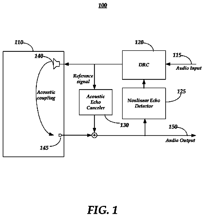
Mitigation of nonlinear echoes by dynamic range compression may be provided.
US 8,660,789 B2 · Assignee: University of Southern California · Inventors: Demiryurek; Ugur et al.
Sheet 1 of 17 from the published document. All sheets in the USPTO PDF
With real-world spatial networks the edge travel-times are time-dependent, where the arrival-time to an edge determines the actual travel-time on the edge. To speed up the path computation, exact and approximate techniques for computation of the fastest path in time-dependent spatial networks are presented. An exact fastest path computation technique based on a time-dependent A* search can significantly improve the computation time and storage complexity of existing approaches. Moreover, for applications with which approximate fastest path is acceptable, the approximate fastest path computation technique can improve the computation time by an order of magnitude while maintaining high accuracy (e.g., with only 7% increase in travel-time of the computed path on average). With experiments using real data-sets (including a variety of large spatial networks with real traffic data) the efficacy of the disclosed techniques for online fastest path computation is demonstrated.
This specification relates to path computation in spatial networks. The problem of point-to-point fastest path computation in spatial networks is extensively studied with many approaches proposed to speed-up the computation. Most of the existing approaches make the simplifying assumption that travel-times of the network edges are constant. With the ever-growing popularity of online map applications and their wide deployment in mobile devices and car-navigation systems, an increasing number of users search for point-to-point fastest paths and the corresponding travel-times. On static road networks where edge costs are constant, this problem has been extensively studied and many efficient speed-up techniques have been developed to compute the fastest path in a matter of milliseconds (e.g., Hanan Samet and Jagan Sankaranarayanan and Houman Alborzi, Scalable Network Distance Browsing in Spat
1 of 17 drawing sheets so far from the published document, cropped to the drawing. Every sheet is in the USPTO PDF.
What the patent claimed, word for word. All of it is now free to use.
This specification relates to path computation in spatial networks.
The problem of point-to-point fastest path computation in spatial networks is extensively studied with many approaches proposed to speed-up the computation. Most of the existing approaches make the simplifying assumption that travel-times of the network edges are constant. With the ever-growing popularity of online map applications and their wide deployment in mobile devices and car-navigation systems, an increasing number of users search for point-to-point fastest paths and the corresponding travel-times. On static road networks where edge costs are constant, this problem has been extensively studied and many efficient speed-up techniques have been developed to compute the fastest path in a matter of milliseconds (e.g., Hanan Samet and Jagan Sankaranarayanan and Houman Alborzi, Scalable Network Distance Browsing in Spatial Databases, SIGMOD, pages 33-40, Toronto, Canada, 2008; Ulrith Lauther, An Extremely Fast, Exact Algorithm for Finding Shortest Paths in Static Networks with Geographical Background, Geoinformation and Mobilitat, pages 33-40, Toronto, Canada, 2004; Wagner, Dorothea and Willhalm, Thomas, Geometric Speed-Up Techniques for Finding Shortest Paths in Large Sparse Graphs, ESA, 2003; P. Sanders and D. Schultes, Highway hierarchies hasten exact shortest path queries, ESA, 2005; and Sanders, Peter and Schultes, Dominik, Engineering fast route planning algorithms, WEA, 2007).
The static fastest path approaches make the simplifying assumption that the travel-time for each edge of the road network is constant (e.g., proportional to the length of the edge). However, in the real-world, the actual travel-time on a road segment heavily depends on the traffic congestion and, therefore, is a function of time i.e., time-dependent. For example, FIG. 1 shows the variation of travel-time 100 (computed by averaging two-years of historical traffic sensor data) for a particular road segment of the I-10 freeway in Los Angeles as a function of arrival-time to the segment. As shown, the travel-time of this segment changes with time (i.e, the time that one arrives at the segment entry determines the travel-time), and the change in travel-time is significant. For instance, from 8 AM to 9 AM the travel-time of this single segment changes from 32 minutes to 18 minutes (a 45% decrease). By induction, one can observe that the time-dependent edge travel-times yield a considerable change in the actual fastest path between any pair of nodes throughout the day. Specifically, the fastest path between a source and a destination node varies depending on the departure-time from the source. Unfortunately, all those techniques that assume constant edge weights fail to address the fastest path computation in real-world time-dependent spatial networks.
In general, an aspect of the subject matter described in this specification can be embodied in a method that includes the actions of: partitioning a road network graph into subgraphs, wherein the road network graph has associated time-dependent edge weights; for each one of the subgraphs, which includes interior nodes and border nodes, determining a minimum lower-bound fastest path cost between the border nodes and the interior nodes of the one subgraph, based on minimum edge weight values in the one subgraph; for each pair of the subgraphs, determining a minimum lower-bound fastest path cost between respective border nodes of the pair of subgraphs, based on minimum edge weight values between the pair of subgraphs; finding a path between a first node in a first of the subgraphs and a second node in a second of the subgraphs using a search directed in accordance with a lower-bound estimator of travel time, the lower-bound estimator being the minimum lower-bound fastest path cost between the border nodes and the interior nodes of the first subgraph, the minimum lower-bound fastest path cost between respective border nodes of the first and second subgraphs, and the minimum lower-bound fastest path cost between the border nodes and the interior nodes of the second subgraph.
These and other embodiments can optionally include one or more of the following features. The search can include a first search and a second search, and the finding can include: running the first search for the road network graph in a forward direction, directed in accordance with the lower-bound estimator of travel time, with the time-dependent edge weights taken into consideration; and running, concurrently with the first search, the second search for the road network graph in a backward direction, directed in accordance with the lower-bound estimator of travel time, with minimum possible travel times substituted for the time-dependent edge weights; wherein, after search frontiers of the first and second searches meet, results of the second search limit nodes to be explored by the first search to find a fastest path. The partitioning can include partitioning the road network graph into the subgraphs based on predefined edge class information for the road network graph. In addition, determining the minimum lower-bound fastest path cost between the border nodes and the interior nodes of the one subgraph can include: determining a minimum lower-bound fastest path cost to any of the border nodes of the one, subgraph for each of the interior nodes of the one subgraph; and determining a minimum lower-bound fastest path cost to any of the interior nodes of the one subgraph for each of the border nodes of the one subgraph.
The partitioning can include partitioning the road network graph into a hierarchy of levels of the subgraphs, the finding can include beginning the search at a first level of the hierarchy and then exploring the hierarchy levels in ascending order, and the method can further include: for each of multiple transit nodes connecting adjacent levels of the hierarchy, precomputing a core region and an extended region around the transit node based on lower-bound and upper-bound graphs corresponding to the road network graph; and identifying one of the multiple transit nodes through which to start searching an adjacent higher level of the hierarchy using the core regions and the extended regions for the transit nodes. The precomputing can include, for each one of the multiple transit nodes, determining the core region by: expanding a fastest path tree from the one transit node using upper-bound travel-time; expanding fastest path trees from remaining ones of the transit nodes using lower-bound travel-times; and stopping expansion of the fastest path tree from the one transit node when it meets the fastest path trees from the remaining ones of the transit nodes. Furthermore, the precomputing can include, for each one of the multiple transit nodes, determining the extended region by: expanding a fastest path tree from the one transit node using lower-bound travel-time; expanding fastest path trees from remaining ones of the transit nodes using upper-bound travel-times; and stopping expansion of the fastest path tree from the one transit node when it meets the fastest path trees from the remaining ones of the transit nodes.
The identifying can Include, for a given node in a first level of the hierarchy: checking the core regions for one such core region having the given node inside; if the one such core region is found, identifying the corresponding transit node as the one of the multiple transit nodes through which to start searching the adjacent higher level of the hierarchy; and if the one such core region is not found, determining a subset of the extended regions that have the given node inside, and if the subset contains only one extended region, identifying the corresponding transit node for the one extended region as the one of the multiple transit nodes through which to start searching the adjacent higher level of the hierarchy, else, identifying a closest transit node, from the transit nodes corresponding to the extended regions of the subset, as the one of the multiple transit nodes through which to start searching the adjacent higher level of the hierarchy. Finally, the method can also include providing a user interface including an element that allows selection of a new departure time, after receipt of a query indicating the first node and the second node, to revise the path found between the first node and the second node based on the new departure time.
The described and claimed methods can be implemented using a computer program encoded on a computer-readable medium or in a larger computer system (e.g., an online mapping and direction finding server system). Thus, according to another aspect of the subject matter described in this specification, a computer-readable medium encodes a computer program product operable to cause data processing apparatus to perform operations in accordance with any of the method claims; and a system can include: a user interface device; and one or more computers that interact with the user interface device, the one or more computers including at least one processor and at least one memory device, where the one or more computers are configured and arranged to perform operations in accordance with any of the method claims.
According to another aspect of the subject matter described in this specification, a computer-readable medium encodes a computer program product operable to cause data processing apparatus to perform operations including: partitioning a road network graph into subgraphs, wherein the road network graph has associated time-dependent edge weights; for each one of the subgraphs, which includes interior nodes and border nodes, determining a minimum lower-bound fastest path cost to any of the border nodes for each of the interior nodes, and determining a minimum lower-bound fastest path cost to any of the interior nodes for each of the border nodes; for each pair of the subgraphs, determining a minimum lower-bound fastest path cost between any two border nodes of the pair; finding a path between a first node in a first of the subgraphs and a second node in a second of the subgraphs using a search directed in accordance with a lower-bound estimator of travel time, the lower-bound estimator being the minimum lower-bound fastest path cost from the first node to a border node of the first subgraph, the minimum lower-bound fastest path cost between any two border nodes of the first and second subgraphs, and the minimum lower-bound fastest path cost from a border node of the second subgraph and the second node. This aspect can also be implemented as a system or a method, and these and other embodiments can optionally include one or more of the method features addressed above.
According to another aspect of the subject matter described in this specification, a system includes: a user interface device; and one or more computers that interact with the user interface device, the one or more computers including at least one processor and at least one memory device, the one or more computers configured and arranged to partition a road network, having associated time-dependent edge weights, into a hierarchy of levels for use in finding a path between nodes of the road network, where the finding includes beginning a search at a first level of the hierarchy and then exploring the hierarchy levels in ascending order, and the one or more computers configured and arranged to, for each of multiple transit nodes connecting adjacent levels of the hierarchy, precomputer a core region and an extended region around the transit node based on lower-bound and upper-bound graphs corresponding to the road network graph, and identify one of the multiple transit nodes through which to start searching an adjacent higher level of the hierarchy using the core regions and the extended regions for the transit nodes. This aspect can also be implemented as a method or a computer-readable medium, and these and other embodiments can optionally include one or more of the method features addressed above.
In addition, in system implementations, the one or more computers can include a server operable to interact with the user interface device through a data communication network, and the user interface device can be operable to interact with the server as a client. The user interface device can include a mobile phone or satellite navigation device. Finally, the one or more computers include be one personal computer, and the personal computer can include the user interface device.
FIG. 1 shows the real-world travel-time pattern on a segment of I-10 freeway in Los Angeles between 6 AM and 8 PM on a weekday.
FIG. 2 shows a spatial network modeled as a time-dependent graph in which edge travel-times are function of time.
FIG. 3A shows Google Maps offering two alternative paths for an origin and destination pair in the Los Angeles road network.
FIGS. 3B-3H show the time-dependent path recommendations for the same origin and destination pair computed using different departure times.
FIG. 4 shows the partitioning of San Joaquin (California) network based on road classes.
FIG. 5 shows path segments corresponding to precomputation of node-to-border, border-to-border, and border-to-node lower-bound travel-times.
FIG. 6 shows forward and backward searches meeting in a bidirectional search.
FIG. 7 shows a hierarchal network with three levels.
FIGS. 8A and 8B show core regions and extended regions for three transit nodes.
FIG. 9A plots the relative error versus time according to a set of experiments.
FIG. 9B plots the variation versus path length according to the set of experiments.
FIG. 10A shows the speed-up with respect to distance according to another set of experiments.
FIG. 10B the response time of U-TDFP compared with time-dependent ALT (TDALT).
FIG. 11A shows the coverage ratio of the core regions with varying transit node cardinalities on two data sets.
FIG. 11B shows the average number of neighbor regions with varying transit node cardinalities.
Section 1--Towards Time-dependent Path Planning: To illustrate why classic fastest path computations in static road networks may return non-optimal results, we show a simple example in FIG. 2 where a spatial network is modeled as a time-dependent graph 200 and edge travel-times are function of time. Consider the snapshot of the network (i.e., a static network) with edge weights corresponding to travel-time values at t=0. With classic fastest path computation approaches that disregard time-dependent edge travel-times, the fastest path from s to d goes through v.sub.1, v.sub.2, v.sub.4 with a cost of 13 time units. However, by the time when v.sub.2 is reached (i.e., at t=5), the cost of edge e(v.sub.2, v.sub.4) changes from 8 to 12 time units, and hence reaching d through v.sub.2 takes 17 time units instead of 13 as it was anticipated at t=0. In contrast, if the time-dependency of edge travel-times are considered and hence the path going through v.sub.3 was taken, the total travel-cost would have been 15 units which is the actual optimal fastest path. We call this shortcoming of the classic fastest path computation techniques as no-lookahead problem. Unfortunately, most of the existing state of the art path planning applications (e.g., Google Maps, Bing Maps) suffer from the no-lookahead shortcoming and, hence, their fastest path recommendation remains the same throughout the day regardless of the departure-time from the source e.g., query time). Although some of these applications provide alternative paths under traffic conditions (which may seem similar to time-dependent planning at first), we observe that the recommended alternative paths and their corresponding travel-times still remain unique during the day, and hence no time-dependent planning is actually performed. To the best of our knowledge, these applications compute top-k fastest paths (i.e., k alternative paths) and their corresponding travel-times with and without taking into account the traffic conditions. The travel-times which take into account the traffic conditions are simply computed by considering increased edge weights (that corresponds to traffic congestion) for each path. However, our time-dependent path planning results in different optimum paths for different departure-times from the source. For example, consider FIG. 3A where Google Maps offer two alternative paths 310 and 320 (and their travel-times under no-traffic and traffic conditions) for an origin and destination pair in the Los Angeles road network. Note that the path recommendation and the travel-times remain the same regardless of when the user submits the query. On the other hand, FIGS. 3B-3H depict the time-dependent path recommendations for the same origin and destination pair where we computed the time-dependent fastest paths for 38 consecutive departure-times between 8 AM and 5:30 PM, spaced 15 minutes apart (note that the paths are computed using the algorithm presented in Section 4 below, where time-dependent edge travel-times are generated based on the two-years of historical traffic sensor data collected from Los Angeles road network).
As shown, the optimal paths change frequently during the course of the day. Moreover, the user interface can include an element that allows selection of a departure time (or a departure time range) either with the initial query submission or after the query submission. Thus, for example, after a source and destination have been set by a query and a fastest path shown to the user (where the departure time can be assumed to be the time the query is received or can be set to a time specified with the query submission), a time slider 350 can be used to change the departure time, and the user interface can be actively updated with a new fastest path in response to changing of the departure time. Furthermore, in some implementations, a departure time range can be specified, and more than one path can be shown in the user interface at once, with the various paths being associated with sub-portions of the time range (e.g., by color coding or by different line patterns).
One may argue against the benefits time-dependent path planning algorithms due to a) unavailability of the time-dependent edge travel-times, or b) negligible gain of time-dependent path planning (i.e., how much time-dependent planning can improve the travel-time) over the static path planning. To address the first argument, note that recent advances in sensor networks enabled instrumentation of road networks in major cities for collecting real-time traffic data, and hence it is now feasible to accurately model the time-dependent travel-times based on the vast amounts of historical data. For instance, at our research center, we maintain a very large traffic sensor dataset of Los Angeles County that we have been collecting and archiving the data for over two years see Section 6.1 for the details of this dataset). As another example, the PeMS project developed by UC Berkeley generates time-varying edge travel-times using historical traffic sensor data throughout California. Meanwhile, we also witness that leading navigation service providers (such as Navteg and TeleAtlas) have already started releasing their time-dependent travel-time datasets for road networks at high temporal resolution (e.g., one sample for every five minutes). With regards to the second argument, several recent research studies showed the importance of time-dependent path planning in road networks where real-world traffic datasets have been used for the assessment. For example, in Ugur Demiryurek and Famoush Banaei Kashani and Cyrus Shahabi, A Case for Time-dependent Shortest Path Computation in Spatial Networks, ACM SIGSPATIAL, 2010, the authors report that the fastest path computation that considers time-dependent edge travel-times in Los Angeles road network decreases the travel-time by as much as 68% over the fastest path computation that assumes constant edge travel-times. A similar observation was made in another study, Baris Guc and Anand Ranganatlian, Real-time, Scalable Route Planning using Stream-Processing Infrastructure, ITS, NJ, USA, 2010, where the time-dependent fastest path computation in a Stockholm road network can improve the travel-time accuracy up to 62%. Considering the availability of high-resolution time-dependent travel-time data for road networks, and the importance of time-dependency for accurate and useful path planning, the need for efficient algorithms to enable next-generation time-dependent path planning applications becomes apparent and immediate.
The time-dependent fastest path problem was first shown by Dreyfus (Stuart E. Dreyfus, An Appraisal of Some Shortest-Path Algorithms, Operations Research Vol. 17, No. 3, 1969) to be polynomially solvable in FIFO (First-In-First-Out) networks by a trivial modification to Dijkstra algorithm where, analogous to shortest path distances, the arrival-time to the nodes is used as the labels that form the basis of the greedy algorithm. The FIFO property, which typically holds for many networks including road networks, suggests that moving objects exit from an edge in the same order they entered the edge. However, the modified Dijkstra algorithm is far too slow for online map applications which are usually deployed on very large networks and require almost instant response times. On the other hand, there are many efficient precomputation approaches that answer fastest path queries in near real-time (e.g., Hanan Samet and Jagan Sankaranarayanan and Houman Alborzi, Scalable Network Distance Browsing in Spatial Databases, SIGMOD, pages 33-40, Toronto, Canada, 2008) in static road networks. However, it is infeasible to extend these approaches to time-dependent networks. This is because the input size (i.e., the number of fastest paths) increases drastically in time-dependent networks. Specifically, since the length of a s-d path changes depending on the departure-time from s, the fastest path is not unique for any pair of nodes in time-dependent networks. It has been conjectured in Dean, Brian C., Algorithms for min-cost paths in time-dependent networks with wait policies, Networks, NJ, USA, 2004, that the number of fastest paths between any pair of nodes in time-dependent road networks can be super-polynomial. Hence, an algorithm which considers every possible path (corresponding to every possible departure-time from the source) for any pair of nodes in large time-dependent networks would suffer from exponential time and prohibitively large storage requirements. For example, the time-dependent extension of Contraction Hierarchies (CH) (Gernot Veit Batz and Daniel Delling and Peter Sanders and Christian Vetter, Time-Dependent Contraction Hierarchies, ALENEX, 2009) and SHARC (Delling, Daniel, Time-Dependent SHARC-Routing, ESA, 2008) speed-up techniques (which are proved to be very efficient for static networks) suffer from the impractical precomputation times and intolerable storage complexity see Section 2). The time-dependent ALT (Daniel Delling and Dorothea Wagner, Landmark-based routing in dynamic graphs, WEA, 2007) approach (also originally developed for static networks) is more efficient than the time-dependent CH and SHARC. However, with ALT the search space is severely affected by the selection of the landmarks. So far no optimal strategy with respect to landmark selection and random queries has been found, and hence ALT does not guarantee to yield the small search spaces with respect to fastest path computations where source and destination nodes are chosen at random. We show that our proposed (exact) solution outperforms time-dependent ALT by a factor of at least four in storage and response time (see Section 6.2).
In this study, we present two different techniques, one exact and one approximate, for online computation of fastest path in large time-dependent road networks. For both of our approaches, we precompute and leverage two time-independent auxiliary graphs corresponding to the time-dependent network graph G, namely the lower-bound graph (G) and the upper-bound graph ( G). To construct G and G substitute the edge travel-times in G with minimum and maximum possible travel-times, respectively. The lower-bound and upper-bound graphs are extremely efficient in pruning the search space for both exact and approximate fastest path computation in time-dependent networks. For our exact fastest path computation technique, we propose a bidirectional time-dependent fastest path algorithm (B-TDFP) based on A* search (Hart, Peter and Nilsson, Nils and Raphael, Bertram, A Formal Basis for the Heuristic Determination of Minimum Cost Paths, IEEE Transactions on Systems Science and Cybernetics, 1968). There are two main challenges to employ bidirectional A* search in time-dependent networks. First, it is generally not possible to implement a backward search without knowing the arrival-time at the destination. Second, finding an admissible heuristic function (i.e., lower-bound distance) between an intermediate v.sub.i node and the destination d is challenging as the distance between v.sub.i and d changes based on the departure-time from v.sub.i. We address the former challenge by running the backward search on G which enables us to filter-in the set of the nodes that are explored by the forward search. To address the latter challenge, we partition the road network to non-overlapping partitions (an off-line operation) and precompute the intra (border-to-border) and inter (node-to-border) partition distance labels with respect to G. We use the combination of intra and inter distance labels as a heuristic function in the online computation. Our experiments showed that B-TDFP is approximately one order of magnitude faster than the time-dependent Dijkstra algorithm.
In our second approach, we develop a hierarchical path finding technique (H-TDFP) for an approximate computation of fastest path. Our motivation is based on the fact that, given the source and destination nodes are sufficiently, far away, humans tend to select paths hierarchically, i.e., drive on a local road which connects to freeway, drive on the freeway to a location nearby the destination, exit freeway and reach the destination via local road. The hierarchical path may not necessarily be the optimal but largely considered as the best path as the higher level road segments offer uninterrupted (e.g., smaller number of turns, no traffic lights travel. With H-TDFP, we start the path search at the first level and then carry out exploring the hierarchy in the network in ascending order. Since the number of nodes at each level shrinks rapidly, the total number of explored nodes is considerably smaller than that of the plain fastest path algorithm. Hence, our solution strikes a compromise between the computation time and the optimality of the fastest path. The main challenge with hierarchical path planning in time-dependent networks is the time it takes to identify the transit node through which we start searching the adjacent higher levels. We address this challenge by precomputing two subnetworks around each transit node called Core Region (CR) and Extended Region (ER) based on the lower-bound and upper-bound graphs, respectively. We compute CRs and ERs by extending a method described in U.S. patent application Ser. No. 13/278,060, filed Oct. 20, 2011, which is hereby incorporated by reference, that has been proposed to find k nearest neighbors in time-dependent road networks. The CRs and ERs enable us to find the best transit node by executing either none or very limited number of fastest path computation. Our experiments show that H-TDFP yields more than one orders of magnitude reduction (as compared to B-TDFP) in the computation time at the expense of only 7% increase in the path travel-time as compared to the optimal solution. To the best of our knowledge, our proposed approach is the first hierarchial path planning solution in time-dependent road networks.
The remainder of this paper is organized as follows. In Section 2, we review the related work on time-dependent fastest path algorithms. In Section 3, we formally define the time-dependent fastest path problem in spatial networks. In Section 4, we establish the theoretical foundation of our proposed bidirectional algorithm and explain our approach. In Section 5, we introduce our hierarchial time-dependent fastest path algorithm. In Section 6, we present the results of our experiments for both approaches with a variety of spatial networks with real-world time-dependent edge weights. Finally, in Section 7, we conclude and discuss our future work.
Section 2--Related Work: In this section, we review previous studies on time-dependent fastest path (TDFP) computation. In the last decade, numerous efficient fastest path algorithms with precomputation methods have been proposed (see Sanders, Peter and Schultes, Dominik, Engineering fast route planning algorithms, WEA, 2007, and Hanan Samet and Jagan Sankaranarayanan and Houman Alborzi, Scalable Network Distance Browsing in Spatial Databases, SIGMOD, pages 33-40, Toronto, Canada, 2008, for an overview). However, there is a limited number of studies for efficient computation of time-dependent fastest path problem.
Cooke and Halsey first studied the time-dependent fastest path problem where they solved the problem by formulating it in discrete-time and using Dynamic Programming (see L. Cooke and E. Halsey, The shortest route through a network with timedependent internodal transit times, Journal of Mathematical Analysis and Applications, NJ, LISA, 1966). Another discrete-time solution to TDFP problem is to utilize time-expanded networks (see Ekkehard Kohler and Katharina Langkau and Martin Skutella, Time-Expanded Graphs for Flow-Dependent Transit Times, Proc. 10th Annual European Symposium on Algorithms, 2002). In general, time-expanded network and discrete-time approaches assume that the edge weight functions are defined over a finite discrete window of time t.epsilon.t.sub.0, t.sub.1, . . . , t.sub.n, where t.sub.n is determined by the total duration of time interval under consideration. Therefore, the problem is reduced to the problem of computing minimum-weight paths over a static network per time window. Hence, one can apply any of the well-known static fastest path algorithms. Although these algorithms are easy to design and implement, they have numerous shortcomings. First, time-expanded models would need to create a separate instance of the network for each time instance hence yielding a substantial amount of storage overhead. Second, such approaches can only provide approximate results because the model misses the state of the network between any two discrete-time instants. Moreover, the difference between the shortest path obtained using the time-expanded model and the optimal shortest path is very sensitive to the parameter n (i.e., number of intervals) and is unbounded. This is because the query time can be always between any two of the intervals which are not captured by the model, and hence the error is accumulated on each edge along the path. Finally, it is very hard to decide on the effective choice of discrete-time intervals for real-world applications. In George, Betsy and Kim, Sangho and Shekhar, Shashi, Spatio-temporal Network Databases and Routing Algorithms: A Summary of Results, SSTD, 2007, George and Shekhar proposed a time-aggregated graph approach where they aggregate the travel-times of each edge over the time instants into a time series. Even though their model requires less space than that of the time-expanded networks, the results are still approximate with no bounds.
In Stuart E. Dreyfus, An Appraisal of Some Shortest-Path Algorithms, Operations Research Vol. 17, No. 3, 1969, Dreyfus showed that the time-dependent fastest problem can be solved by a generalization of Dijkstra's method as efficiently as for static fastest path problems. However, Halpern proved (in J. Halpern, Shortest route with time dependent length of edges and limited delay possibilities in nodes, Mathematical Methods of Operations Research, 1969) that the generalization of Dijkstra's algorithm is only true for FIFO networks. If the FIFO property does not hold in a time-dependent network, then the problem is NP-Hard. In Orda, Ariel and Rom, Raphael, Shortest-path and minimum-delay algorithms in networks with time-dependent edge-length, J. ACM, 1990, Orda and Rom introduced a time-dependent fastest path approach based on Bellman-Ford algorithm. With their approach, they determine the path toward destination by refining the arrival-time functions on each node in the whole time interval T. In Kanoulas, Evangelos and Du, Yang and Xia, Tian and Zhang, Donghui, Finding Fastest Paths on A Road Network with Speed Patterns, ICDE, Washington, USA, 2006, Kanoulas et al. introduced a Time-Interval All Fastest Path (allFP) approach in which they maintain a priority queue of all paths to be expanded instead of sorting the priority queue by scalar values. Therefore, they enumerate all the paths from the source to a destination node which incurs exponential running time in the worst case. In Ding, Bolin and Yu, Jeffrey Xu and Qin, Lu, Finding time-dependent shortest paths over large graphs, EDBT, New York, N.Y., USA, 2008 ACM, Ding et al. used a variation of Dijkstra's algorithm to solve the TDFP problem. With their TDFP algorithm, using Dijkstra like expansion, they decouple the path-selection and time-refinement (computing earliest arrival-time functions for nodes) for a given starting time interval T. Their algorithm is also shown to run in exponential time for special cases (see Dehne, Frank and Omran, Masoud T. and Sack, Jorg-Rudiger, Shortest paths in time-dependent FIFO networks using edge load forecasts, IWCTS, 2009). The focus of both Kanoulas, Evangelos and Du, Yang and Xia, Tian and Zhang, Donghui, Finding Fastest Paths on A Road Network with Speed Patterns, lCDE, Washington, USA, 2006 and Ding, Bolin and Yu, Jeffrey Xu and Qin, Lu, Finding time-dependent shortest paths over large graphs, EDBT, New York, N.Y., USA, 2008 ACM is to find the fastest path in time-dependent road networks for a given start time interval (e.g., between 7:30 AM and 8:30 AM).
The ALT algorithm (Andrew V. Goldberg and Chris Harellson, Computing the Shortest Path: A* Search Meets Graph Theory, SODA, pages 422-432, 2005) was originally proposed to accelerate fastest path computation in static road networks. With this approach, a set of nodes called landmarks are chosen and then the shortest distances (in travel-time) between all the nodes in the network and all the landmarks are computed and stored. ALT employs triangle inequality based on distances to the landmarks to obtain a heuristic function to be used in A* search. The time-dependent variant of this technique is studied in Daniel Defling and Dorothea Wagner, Landmark-based routing in dynamic graphs, WEA, 2007, where heuristic function is computed with respect to a lower-bound graph. However, with ALT, the landmark selection is very difficult (relies on heuristics) and the size of the search space is severely affected by the choice of landmarks. So far no optimal strategy with respect to landmark selection and random queries has been found. Specifically, landmark selection is NP-hard (see Potamias, Michalis and Bonchi, Francesco and Castillo, Carlos and Gionis, Aristides, Fast shortest path distance estimation in large networks, CIKM, 2009) and ALT does not guarantee to yield the smallest search spaces with respect to fastest path computations where source and destination nodes are chosen at random. Our experiments with real-world time-dependent travel-times show that our exact approach consumes much less storage as compared to ALT and yields faster response times (see Section 6). In two different studies. The Contraction Hierarchies (CH) and SHARC methods (also developed for static networks) were augmented to time-dependent road networks. The main idea of these techniques is to remove unimportant nodes from the graph without changing the fastest path distances between the remaining (more important) nodes. However, unlike the static networks, the importance of a node can change throughout the time under consideration in time-dependent road networks, hence the importance of the nodes are time varying. Considering the super-polynomial input size (as discussed in Section 1), and hence the super-polynomial number of important nodes with time-dependent networks, the main shortcomings of these approaches are impractical preprocessing times and extensive space consumption. For example, the precomputation time for SHARC in time-dependent road networks takes more than two days for relatively small road networks (e.g. Germany). While CH also suffers from slow preprocessing times, the space consumption for CH is at least 1000 bytes per node for less varied edge-weights (e.g., weekend travel time patterns) where the storage cost increases with real-world time-dependent edge weights. Therefore, it is not feasible to apply SHARC and CH to continental size road networks which can consist of up to 45 million road segments (e.g., North America road network) with possibly large varied edge-weights.
Section 3--Problem Definition: There are various criteria to define the cost of a path in road networks. In our study we define the cost of a path as its travel-time. We model the road network as a time-dependent weighted graph as shown in FIG. 2 where the non-negative time-dependent travel-times are provided as a function of time which captures the typical congestion pattern for each segment of the road network. We use piecewise linear functions to represent the time-dependent travel-times in the network.
Definition 1. Time-dependent Graph. A Time-dependent Graph is defined as G(V,E,T) where V={v.sub.i} is a set of nodes and EV.times.V is a set of edges representing the network segments each connecting two nodes. For every edge e(v.sub.i,v.sub.j).epsilon.E, and v.sub.i.noteq.v.sub.j, there is a cost function c.sub.v.sub.i.sub.,v.sub.j(t), where t is the time variable in time domain T. An edge cost function c.sub.v.sub.i.sub.,v.sub.j(t) specifies the travel-time from v.sub.i to v.sub.j starting at time t.
Definition 2. Time-dependent Travel Cost. Let {s=v.sub.1, v.sub.2, . . . , v.sub.k=d} denotes a path which contains a sequence of nodes where e(v.sub.i, v.sub.i+1).epsilon.E and i=1, . . . , k-1. Given a G(V,E,T), a path (sd) from source s to destination d, and a departure-time at the source t.sub.s, the time-dependent travel cost TT(sd,t.sub.s) is the time it takes to travel the path. Since the travel-time of an edge varies depending on the arrival-time to that edge, the travel-time of a path is computed as follows:
.function..times..times..times..times..function..times..times..times. ##EQU00001## .function..times. ##EQU00001.2##
Definition 3. Lower-bound Graph. Given a G(V,E,T), the corresponding Lower-bound Graph G(V,E) is a graph with the same topology (i.e, nodes and edges) as graph G, where the weight of each edge c.sub.v.sub.i.sub.,v.sub.j is fixed (not time-dependent) and is equal to the minimum possible weight
##EQU00002## where
.A-inverted..function..di-elect cons..di-elect cons..times..times..ltoreq..function. ##EQU00003##
Definition 4. Lower-bound Travel Cost. The lower-bound travel-time LTT(sd) of a path is less than the actual travel-time along that path and computed with respect to G(V,E) as
.function..times..times..times..times..times. ##EQU00004##
The description continues in the full USPTO document.
About 6,099 words. The USPTO PDF has it with every drawing.
Fees are due 3.5, 7.5 and 11.5 years after grant. This patent expired on February 25, 2026, so the fee marked "not paid" was the one that went unpaid.
Hierarchical and Exact Fastest Path Computation in Time-dependent Spatial Networks
Filed Apr 2012 · published Nov 2012Hierarchical and exact fastest path computation in time-dependent spatial networks
Filed Apr 2012 · granted Feb 2014Earlier publications, parents and continuations. None of them can still be enforced, or this patent would not be listed.
Prior art cited by the examiner or applicant. Useful when you check your own idea for novelty.
Everything on this page comes from the documents linked above.